News for hackers. Stuff that matters.
Re:Back-ups for GPS: Satellite-navigation systems at risk of... by sn_master on Friday May 07, 2021 @09:47PM (#27082865)
With modern software, shouldn't it be possible to create accurate kit that can determine the location up to few hundred feet based on pictures we take of the Sun or moon, compass and altitude reading? I thought sailors in the old times could do it with just their head and primitive tools, with modern cameras and compute power I figured we can do better.

In Ben Rich's SkunkWorks, he said the SR-71 had a similar system that would lock onto stars, but I am not sure if it could work when its cloudy, something that's not a problem when you're flying above the clouds, but should still be handy for the airforce or even navy if they can get small drones.

Re:Back-ups for GPS: Satellite-navigation systems at risk of... by numpad0 on Friday May 07, 2021 @11:09PM (#27083434)
The way I always imagined satellite star sensors was like then-cutting edge megapixel cameras but a lot of early “star tracker” sensors were more like a single intensity sensor that rotates on an axis.

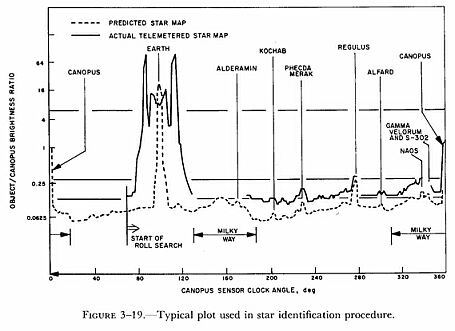
As the sensor(or sometimes the whole satellite) rotates, there’s wide blanking period where sensor is registering the Earth, then there will be series of peaks with specific known range of intensities, like ping ping pause ping ... that ends with sensor registering strobe from the Sun. Either the time from one peak to another or time from end of blanking to some peaks can be measured and “correlated against database”, in reality added and multiplied with just few int values, and positions as well as angular velocity can be calculated.

Being familiar with PC culture, I feel like I tend to overestimate complexity of then-classified military technologies. It’s pleasantly surprising how simple and elegant those classical systems can be.

Re:Back-ups for GPS: Satellite-navigation systems at risk of... by runlevel1 on Friday May 07, 2021 @11:40PM (#27083602)
Fascinating! I'd always wondered how they made it work with 60s-era technology, but when I searched I couldn't find much info on it. This answers some of my questions.

Any pointers on where I can read more?

Re:Back-ups for GPS: Satellite-navigation systems at risk of... by labcomputer on Saturday May 08, 2021 @01:43AM (#27084261)
http://www.prc68.com/I/StellarTime.shtml#P

The Northrop patents are probably the most interesting. IIRC, if you trace the prior art, you’ll find some patents from the early days of WWII.

How they work:

* Telescope on an alt-az mount, preferably on the ground or a gimbaled platform linked to an INS.

* Optical wedge (prism) behind a telescope to nutate the image around the optical axis

* A rotating shutter behind the wedge, centered on the telescope’s optical axis (often a starburst pattern, but several of the patents propose different shutter patterns to mitigate the effect of background luminosity gradient). The shutter is phase locked to the prism.

* Ground glass screen at the telescope’s focal point

* Single-pixel optical sensor (PMT in the 1960’s, but you’d use a photodiode today) sensitive to the entire screen

* lock-in amplifier synced to the shutter (note, however, that the patents do not describe it as such)

The lock-in senses the output from the PMT. Phase and magnitude from the lock-in operate the azimuth and altitude servos of the telescope to center on the tracked star.

When the tracked star is centered in the telescope, it makes a circular pattern on the screen, modulated by the shutter. When the star is off-axis the circular path is offset, so the instantaneous modulation frequency depends on the phase of the prism (it helps to see the figures in the patents).

They also put an IR-pass filter somewhere in the system to cut down on scattered light from the atmosphere, which helps to improve the SNR. I’m not sure the filter is strictly necessary because the LIA should give you dozens of dB of processing gain and navigation stars are visible to the eye in a telescope during daytime—but it seems like “free” SNR.

Re:Back-ups for GPS: Satellite-navigation systems at risk of... by numpad0 on Tuesday May 11, 2021 @01:09PM (#27120604)
I couldn't find the picture so spoke from memory and the details were quite wrong, but looks like "canopus sensor"[1] on Mariner spacecrafts was what I had in mind.

1: http://petermasek.50megs.com/starplot.jpg (mirror: https://images.app.goo.gl/9xAn7ATPMSKYLEHs8)
Re:Back-ups for GPS: Satellite-navigation systems at risk of... by aphextron on Friday May 07, 2021 @09:51PM (#27082893)
This is why all modern navy ships still carry sextants and train extensively in celestial navigation. It's pretty much a forgone conclusion that GPS will become immediately useless in any large scale nation state war of the future.
Re:Back-ups for GPS: Satellite-navigation systems at risk of... by sn_master on Friday May 07, 2021 @09:53PM (#27082908)
Yeah, maybe we can have a "digital" sextant that instead of relying on specialized training to humans, just pushes all the sextant data plus altitude, barometer, universal time (UTC), timezone and sunset/sunrise from a perpetual calendar and such inputs to an android gizmo that gives us an approximate location, something that can be sold commercially for hikers, boaters and everyone for fun.
Re:Back-ups for GPS: Satellite-navigation systems at risk of... by nradov on Friday May 07, 2021 @11:32PM (#27083565)
Automated stellar navigation systems have been around for decades.

https://www.thedrive.com/the-war-zone/17207/sr-71s-r2-d2-cou...

Re:Back-ups for GPS: Satellite-navigation systems at risk of... by mikewarot on Friday May 07, 2021 @10:15PM (#27083063)
A sextant requires a flat level horizon, and sky clear enough to see the sun, or stars at night, and a compass that indicates true north (with correction for magnetic declination). In an urban environment, there is usually not a clear shot at a flat horizon, nor an area free from metal structures for far enough to get an accurate magnetic north.
Re:Back-ups for GPS: Satellite-navigation systems at risk of... by sn_master on Friday May 07, 2021 @10:19PM (#27083095)
Shouldn't a gyroscope compensate or at least allow getting flat level? I think maybe they didn't use it because they didn't have accurate gyroscopes we have now.

For clear shot, would tiny drones that go up work? How high do we need to get a clear shot?

Re:Back-ups for GPS: Satellite-navigation systems at risk of... by mikewarot on Saturday May 08, 2021 @12:20AM (#27083835)
Go outside, do you see a flat level horizon?

You could use the accelerometer to get a good idea of "down" but not enough resolution for navigation.

Re:Back-ups for GPS: Satellite-navigation systems at risk of... by therein on Friday May 07, 2021 @10:18PM (#27083083)
All the more reasons to use something digital, isn't it? Would make it much easier to figure out the horizon without actually seeing it.
Re:Back-ups for GPS: Satellite-navigation systems at risk of... by throw0101a on Friday May 07, 2021 @11:15PM (#27083478)
Re:Back-ups for GPS: Satellite-navigation systems at risk of... by salawat on Friday May 07, 2021 @11:00PM (#27083383)
You cannot escape the burden of training people to do it, because someone has to check the machines figures for drift due to defect, improper implementation, or damage.

See the Patriot missile systen fiasco.

Re:Back-ups for GPS: Satellite-navigation systems at risk of... by VistaBrokeMyPC on Friday May 07, 2021 @11:06PM (#27083415)
Navy also uses inertial navigation. It needs to be calibrated with GPS every now and then but you can get away without a GPS downlink for a while before drift becomes a problem.
Re:Back-ups for GPS: Satellite-navigation systems at risk of... by ravel-bar-foo on Saturday May 08, 2021 @04:14AM (#27085022)
I bet it's also why cruise missiles use terrain navigation.
Re:Back-ups for GPS: Satellite-navigation systems at risk of... by labcomputer on Saturday May 08, 2021 @01:57AM (#27084334)
Yup. This open source software will do that for arbitrary star fields: http://astrometry.net/

You still need the camera’s orientation relative to earth and time to get your coordinates though.

Re:Back-ups for GPS: Satellite-navigation systems at risk of... by throw0101a on Friday May 07, 2021 @11:16PM (#27083487)
> With modern software, shouldn't it be possible to create accurate kit that can determine the location up to few hundred feet based on pictures we take of the Sun or moon, compass and altitude reading?

Unless it's cloudy.

Re:Back-ups for GPS: Satellite-navigation systems at risk of... by Arelius on Saturday May 08, 2021 @12:17AM (#27083815)
Don’t you also need a clock to do this?