Re:Open-Source Clojure Library for Geospatial Information
by prospero on Wednesday October 29, 2014 @06:20AM
(#8526387)
Can you expand on what the esoteric topic is and its application?
[ Parent
| on HN ]
Re:Open-Source Clojure Library for Geospatial Information
by dagw on Wednesday October 29, 2014 @07:31AM
(#8526590)
Translating between coordinate systems and basically anything that involves mapping and measuring in 3 dimensions on an irregular not-quite-spherical surface is really hard to get right.
Re:Open-Source Clojure Library for Geospatial Information
by jimktrains2 on Wednesday October 29, 2014 @08:12AM
(#8526719)
I didn't make this picture, but it gives a good idea on the "irregular not-quite-spherical surface" part.
http://alienspacesciencenews.files.wordpress.com/2013/10/an-...
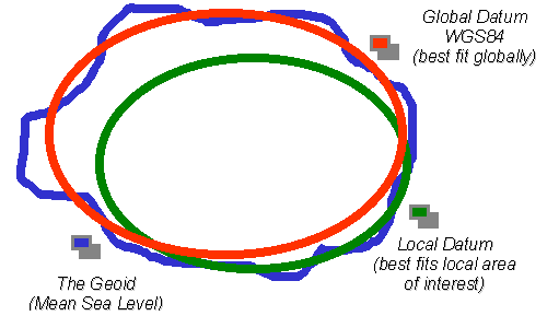
The Local Datum could be NAD83 or what-have-you based on where you are on the surface. Using the local datum gives better distance measurements and more accurately can represent elevation.