I'm a sucker to GPS as well!
Are the maps specialised for orienteering? Since I've never seen that info on a standard street paper map.
Is it something that a digital compass could automatically do? Especially since the article is indicating that magnetic north drifts.
The older the map the less useful it is. You then have metal in the local rocks which can cause problems.
Terrain recognition is far easier, there is far more error correction built in, but if you are hit by a patch of fog and visibility is down in to 30m (let alone 3m!) you need dead reckoning.
Trouble is even a 1 degree error can turn into significant errors after a very short distance.
The magenta dashed line going from top to bottom at a slight angle on the left of this image indicates degrees magnetic declination. https://www.faa.gov/air_traffic/flight_info/aeronav/media/VF...
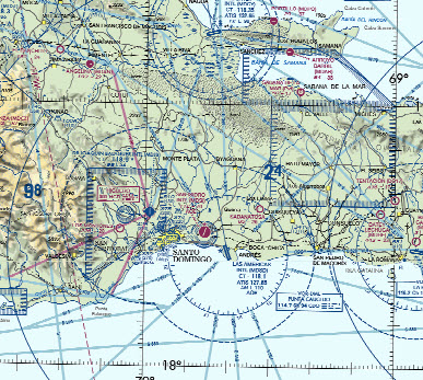
As for specialized maps for orienteering: Orienteering maps are different than normal street maps. They always have gridlines, very precise scales and clear markings of major and minor terrain features[2].
Then, on top of the data presented on a map you have maps of different scales. For example, one inch of a 1:24,000(pronounced - one over twenty four thousand) map represents 24,000 inches on the ground. A 1:250,000 map it very zoomed out relative to a 1:10,000 map.
If you're hiking 500 miles of the PCT you may want a 1:100,000 or 1:250,000 scale map because you don't need to know every twist and turn because you're following a trail.
But if I dropped you off in the middle of nowhere and said walk due west to a specific point 10 kilometers due westyou'd want a map that's 1:10,000-1:24,000 scale because you need to see specific terrain features.
To answer your question more directly: There are what you would "orienteering-specific" maps because they represent some critical data well. For orienteering you use the one that works for you based on what information you need to get you from point A-B
[1] - https://www.idownloadblog.com/2017/04/28/how-to-iphone-compa... [2] - https://pubs.usgs.gov/unnumbered/70039582/report.pdf
Useful tool: http://www.magnetic-declination.com
That said, orienteering is one of the most valuable skills I think a person can learn but it can be hard to grasp learning solo. For those not familiar there are really two ways to go about it: - Dead Reckoning - Terrain Association
Dead Reckoning is all about planning waypoints and using your compass and pace count to get you there. For example: I need to walk 5km at 220° then 2km at 90°, etc.
On top of that, it's easy to make simple mistakes when planning your route. Errors when converting from grid to magnetic(and visa versa) can put you off by a few grid squares so it's important to understand terrain association which is a technique of studying the terrain on a map, plan a route and use those visual terrain features to guide you(If the river is supposed to be on your left but it's on your right, something is wrong).
Having both techniques in your back pocket are essential, but like any skill, they're perishable so you have to practice often.
Some key mistakes people tend to make when orienteering: - When you're dead reckoning through the forest, make sure you switch which side you favor. For example, if your compass points directly at a tree do you step to the right of it to go around or to the left? Most people will pick their dominant side and tend to veer to the right over time. This won't be corrected by staying on a specific azimuth. - Night time is challenging when orienteering in a forest with no roads/creeks/etc to handrail. You often can't see more than 10-20 meters and there's no terrain for you to associate with. - After you plan your waypoints out, do it again from scratch. You likely made a mistake. The protractor you used to get your heading represents your grid angle, every map will have a GM Adjustment(grid to magnetic) you'll need to make.
Source: I'm a former US special ops soldier with hundreds of hours using a map and compass humping through the woods.