News for hackers. Stuff that matters.
Re:Last satellite in the Indian Regional Navigation Satellit... by vardump on Friday April 13, 2018 @05:08AM (#16828212)
So my phone can use these satellite navigation systems: U.S. GPS, Russian GLONASS, European Galileo, Chinese BeiDou and Japanese QZSS.

I guess one more doesn't hurt, huh?

It's curious how major powers all want to have their own satellite navigation systems.

Edit: QZSS is a regional system, and not due to start until November 2018, yet my phone detected one of those satellites earlier about 2-3 weeks ago. Interesting, especially considering I'm nowhere near Japan. Unless, of course, it was a bug or some weird error case. Or maybe QZSS was doing some early testing?

Re:Last satellite in the Indian Regional Navigation Satellit... by azernik on Friday April 13, 2018 @05:33AM (#16828335)
These are essential national security assets, used for military purposes, and which a hostile (or even neutral) owner could turn off in case of war. The civilian use-case is a handy side benefit.
Re:Last satellite in the Indian Regional Navigation Satellit... by nradov on Friday April 13, 2018 @08:48AM (#16829449)
I've listened to interviews with the creators of GPS and they were very clear that it was always intended as a dual use military / civilian system.
Re:Last satellite in the Indian Regional Navigation Satellit... by walrus01 on Friday April 13, 2018 @08:29PM (#16835100)
It's always been that way, I mean, the master gps control station is a very highly guarded USAF base in Colorado.
Re:Last satellite in the Indian Regional Navigation Satellit... by andygates on Friday April 13, 2018 @08:09AM (#16829182)
Was a handy side-benefit, then GPS got so cheap and ubiquitous people tag their dogs and hire bikes. Now, location services are an essential civilian service.
Re:Last satellite in the Indian Regional Navigation Satellit... by heneryville on Friday April 13, 2018 @04:38PM (#16833712)
A number of devices are theorized to use GPS for cryptographic randomness, such as ATMs. In 2007 the US navy accidentally jammed San Diego's GPS signal, but the effect wasn't too huge.

https://fieldlogix.com/news/navy-accidentally-jammed-gps-sys...

Re:Last satellite in the Indian Regional Navigation Satellit... by pc86 on Friday April 13, 2018 @12:44PM (#16831645)
Just because someone tags their dog doesn't make it an essential civilian service.
Re:Last satellite in the Indian Regional Navigation Satellit... by azernik on Friday April 13, 2018 @08:43AM (#16829418)
But that's not the reason why all these countries feel the need to launch their own. If that was what India cared about they'd happily stick to GPS.
Re:Last satellite in the Indian Regional Navigation Satellit... by 215163831328308 on Friday April 13, 2018 @05:17AM (#16828250)
If you build your missiles to work using gps (as another poster pointed out), then you also want those to work if the US decides to not let you use the gps system.
Re:Last satellite in the Indian Regional Navigation Satellit... by jessriedel on Friday April 13, 2018 @06:00AM (#16828460)
> ...my phone detected one of those satellites earlier about 2-3 weeks ago. Interesting, especially considering I'm nowhere near Japan.

Could be an error, but you could just be in Australia or just about anywhere on the Eastern hemisphere. The orbits are geosynchronous and thus very high.

https://en.wikipedia.org/wiki/Quasi-Zenith_Satellite_System#...

Re:Last satellite in the Indian Regional Navigation Satellit... by robocat on Friday April 13, 2018 @07:21AM (#16828904)
Definitely not geosynchronous. It is a Quasi-Zenith Satellite System as per your link.

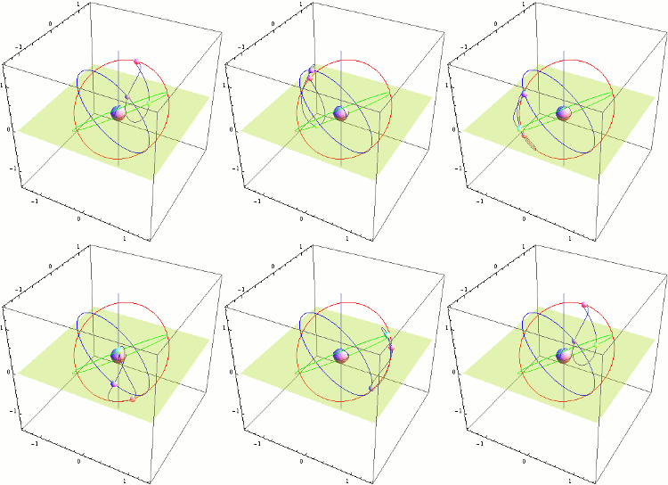
A lovely animation of three satellites: https://upload.wikimedia.org/wikipedia/commons/b/ba/Qzss-01-...
Re:Last satellite in the Indian Regional Navigation Satellit... by vardump on Friday April 13, 2018 @07:58AM (#16829113)
https://en.wikipedia.org/wiki/Quasi-Zenith_Satellite_System#...

"QZSS uses three satellites, each 120° apart, in highly inclined, slightly elliptical, geosynchronous orbits. Because of this inclination, they are not geostationary; they do not remain in the same place in the sky. Instead, their ground traces are asymmetrical figure-8 patterns (analemmas), designed to ensure that one is almost directly overhead (elevation 60° or more) over Japan at all times."

Re:Last satellite in the Indian Regional Navigation Satellit... by robocat on Monday April 16, 2018 @05:24AM (#16847714)
Ahhhh: geosynchronous versus geostationary. I hope I wasn't the only confused muppet!
Re:Last satellite in the Indian Regional Navigation Satellit... by samnardoni on Friday April 13, 2018 @12:39PM (#16831606)
That animation clearly shows they are geosynchronous?
Re:Last satellite in the Indian Regional Navigation Satellit... by orf on Friday April 13, 2018 @05:28AM (#16828311)
How can you tell which nav systems your phone can see?
Re:Last satellite in the Indian Regional Navigation Satellit... by vardump on Friday April 13, 2018 @05:30AM (#16828325)
Android API provides this:

https://developer.android.com/reference/android/location/Gns...

https://developer.android.com/reference/android/location/Gns...

You can also use apps like GPS Test [0], etc. They can tell it as well. QZSS is represented by square icon(s) in that app.

[0]: https://play.google.com/store/apps/details?id=com.chartcross... (not affiliated with them in any way)

Re:Last satellite in the Indian Regional Navigation Satellit... by jhayward on Friday April 13, 2018 @04:58PM (#16833856)
QZSS has been in test phase since 2010, and has had a full constellation of 4 satellites since last year.
Re:Last satellite in the Indian Regional Navigation Satellit... by fellellor on Monday April 16, 2018 @05:41AM (#16847758)
I don't think IRNSS covers regions outside South Asia.